Ronda
last update: 31 December 2020
A travel writer in the early to mid-1800's wrote of Spain,…
"Región of romance!
Of snow-capped mountains, dark forests, and crystal streams!
Land of the olive and the vine, the perfumed orange and bright pomegranate!
Country of portly priests, fierce bandits, and dark-eyed donzellas!
And thou, fair Boetica!
Favoured province of a favoured clime, whose waving cornfields and hidden treasures
have ever since excited the cupidity of the various ambitious nations"
Boetica, refers to what the Romans called Hispania Baetica, a land that existed between the 14th century BC and 711 AD when it became part of Al-Andalus under the Moors.
Introduction
We spent Christmas 2020 in Ronda, which Wikipedia tells us is a town located some 100 km inland from Málaga. What it does not say is that Ronda is one of the 'classical' day-out trips for tourists visiting the Costa del Sol.
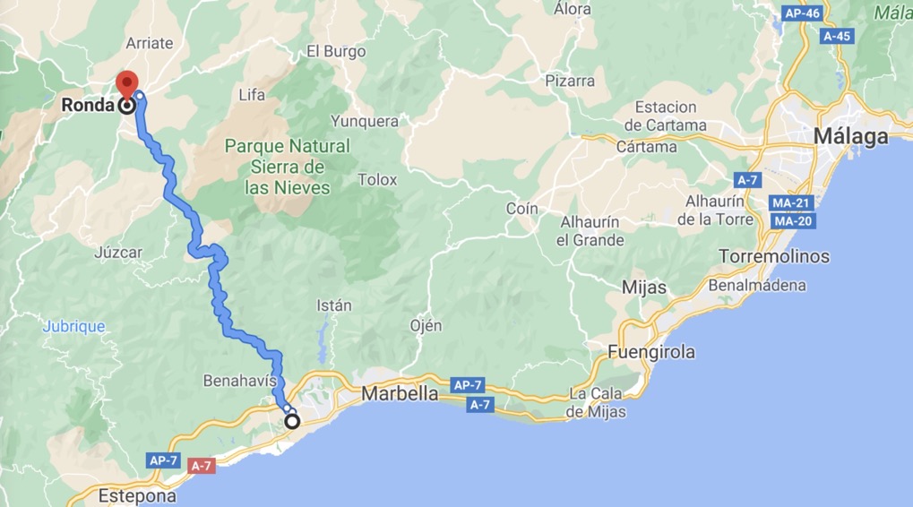
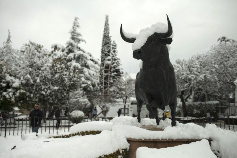
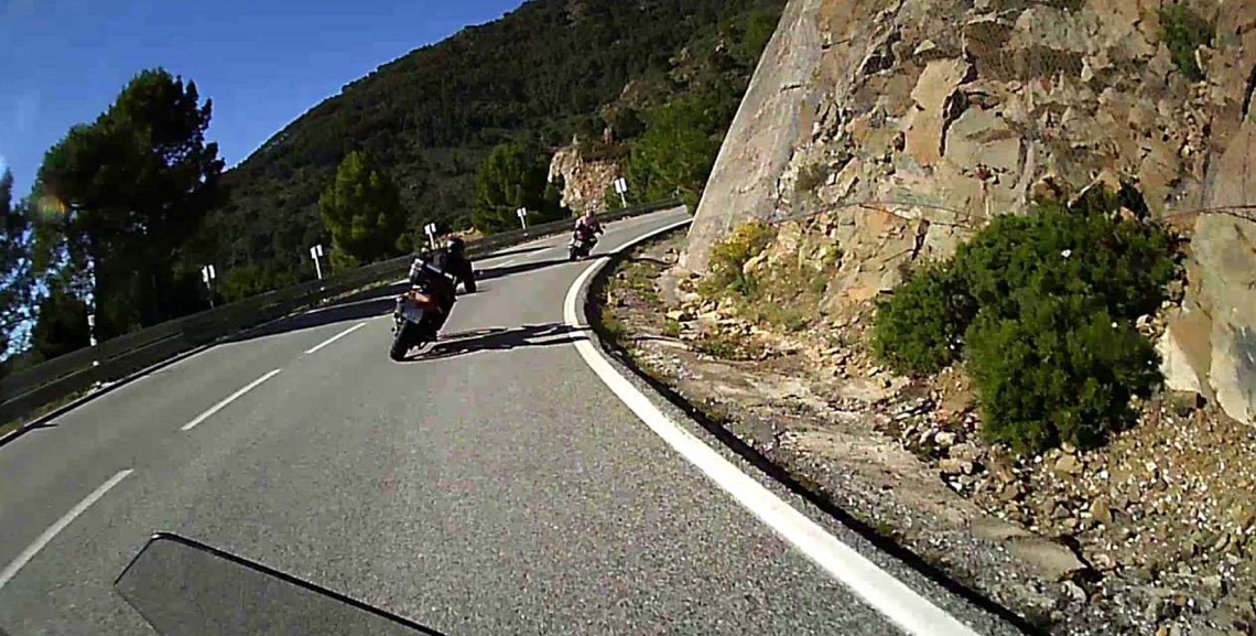
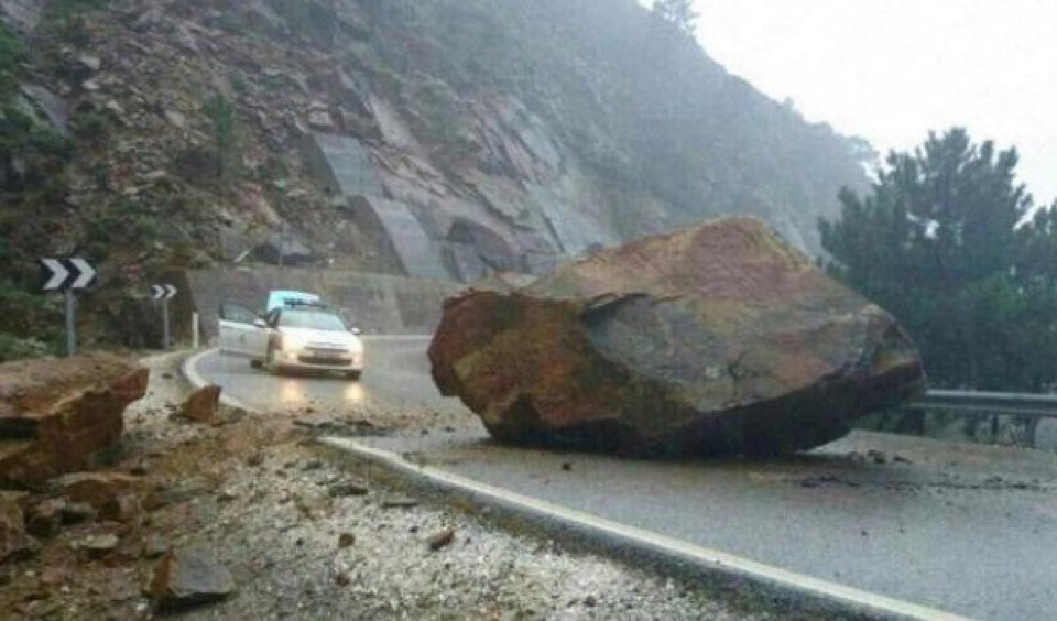
The most obvious route is the A-397 that goes from San Pedro Alcántara to Ronda. It is a relatively modern, windy road that is much appreciated by motorcyclists (it has 365 curves along 45 km). The views can be quite spectacular, but there is always the risk of falling rocks, fog, animals crossing the road, occasional winter ice, and very occasionally snow. And just to prove it, below we have one of the famous statues outside the Ronda bullring.
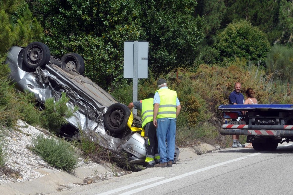
As with all roads, the risks are limited, until they are not. On our drive up to Ronda we saw an accident where the drive had clearly come off the road and was upside-down in a ditch (fortunately on the 'good' side of the road). The road is well used, with nearly 20,000 vehicles daily, so patience is needed because overtaking buses and lorries can be quite dangerous.
The initial part of the A-397, through Benahavís, is one of the richest residential areas along the coast, e.g. houses on the La Zagaleta can easily exceed €5 million.
A warning to everyone, the A-397 has two fixed radars (one is an 'average speed' camera) and two mobile stations, and one of the cameras looks for those driving without their seat belts or whilst talking on a mobile phone, i.e. it spots idiots.
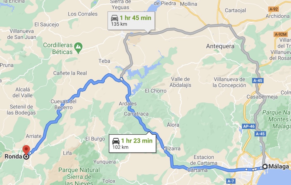
It must be the said that the A-397 is certainly the simplest and fastest route from the coast to Ronda, but there are other, perhaps more scenic routes. One example is from Málaga to Ronda, via A-357 and A-367.
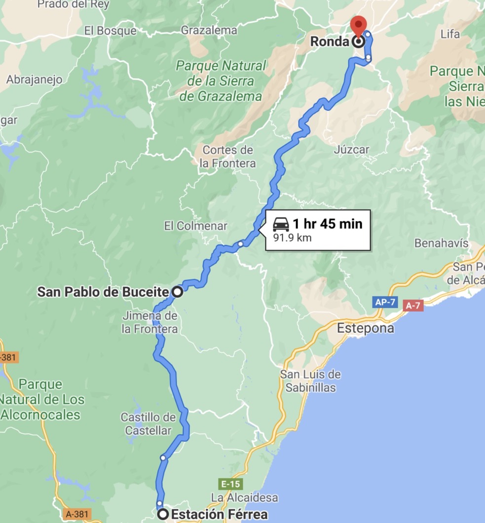
And another famous route is from the San Roque (Estación Férrea) to Ronda, along the A-405 and A-369. The route passes through some of the white villages, e.g. Jimena de la Frontera, San Pablo de Buceite, and Gaucín (see below). The route can easily be slower than indicated on the map, with the A-405 being considered one of the most dangerous in the region for road accidents. However, the A-369 is considered one of the most beautiful roads in Spain.
An alternative is the train from San Roque-La Linea to Ronda. Tickets can be booked online, and you can even get to Granada, Málaga, Cordoba and Madrid from there. I think that there are two trains daily to Madrid, through Ronda, and in addition there are another three 'local' trains. Here is the nice history of this rather particular train line.
Before we visit Ronda today, lets for a moment return to that same travel writer to understand the route he took nearly 200 years ago. A route that took him a day to go from Gibraltar to San Roque, another day to get to Gaucín, and finally a third day to arrive in Ronda.
It is scarcely possible to imagine more romantic and, at the same time, more varied scenery than that which presents itself between Gaucín and Ronda.
For the greater part of the first three leagues (full fourteen English miles) to Atájate, the road winds along the summit of a low mountain chain, the western side of which slopes gracefully to the clear and tortuous Guadiaro, whilst the eastern falls abruptly to the dark and rapid Genal.
In some places, the width of the mountain ridge exceeds but little that of the road itself; enabling the traveller to embrace the two valleys at one glance, and compare their respective beauties. The difference between them is very remarkable, for whilst the sides of both are clothed with the richest vegetation, yet the more gentle character of the one has encouraged the husbandman to devote his labour principally to the culture of hemp and the vine, whereas, the steep and broken banks of the other, being less accessible to the plough, are mostly planted with groves of fig, olive, chestnut, and almond trees.
For the same reason, though both valleys are studded with vil!ages, yet those along the sloping banks of the Guadiaro are large, and distant from each other, whilst, in the more contracted valley of the Genal, almost every isolated crag is occupied by a group of houses, or a dilapidated fortilage, mementoes of the Saracenic occupation.
Beyond the valleys on either side, rise chains of rugged mountains, some covered to their very peaks with dark forests of pine and ilex, others rearing their pointed summits beyond the bounds of vegetation.
The eastern chain is that which borders the Mediterranean shore between Estepona and Marbella. The western is the yet more lofty Sierra that divides the waters of the Guadiaro and Guadalete, directing the former to the Mediterranean, the latter to the Atlantic.
Through the passes between the huge peaks that break the summit of this bold range, an occasional glimpse may be caught of the low and far distant ground about Cádiz and Chiclana. But the view that most excites the traveller's admiration is obtained from a knoll on the road side, about three miles from Gaucin, looking back on that place, and down the verdant valley of the Genal.
The ruins of the old Moorish fortress occupy the right of the picture, the cragged ridge on which it is perched jutting boldly into the valley. And standing out in fine relief from the bright, vine-clad slope of the impending Sierra del Hacho, are yet more distant mountains. To the left, the view is bounded by the rugged peaks of the Sierra Cristellina, from the foot of which a dense but variegated forest spreads entirely across the valley, wherein may here and there be traced the snake-like course of the impatient Genal.
Further on, the valley presents a wider opening, but the little stream still has to struggle for a passage amongst the wide spreading roots of the retiring mountains, which, overlapping each other in rapid succession, present, for many miles, a most singularly furrowed country.
Calpe's fantastic peaks rear themselves above all these intermediate ridges, marking the boundary of Europe. Whilst, to the left of the celebrated promontory, Ceuta may be seen, stretching far into the glassy Mediterranean, and to the right, the huge Sierra Bullones, falling perpendicularly to the Straits of Gibraltar.
In the extreme distance, the African mountains rise in successive ranges, until closed by the chain of the lower Atlas, the faint blue outline of which may be distinctly traced in this transparent atmosphere, although at a distance of at least one hundred miles.
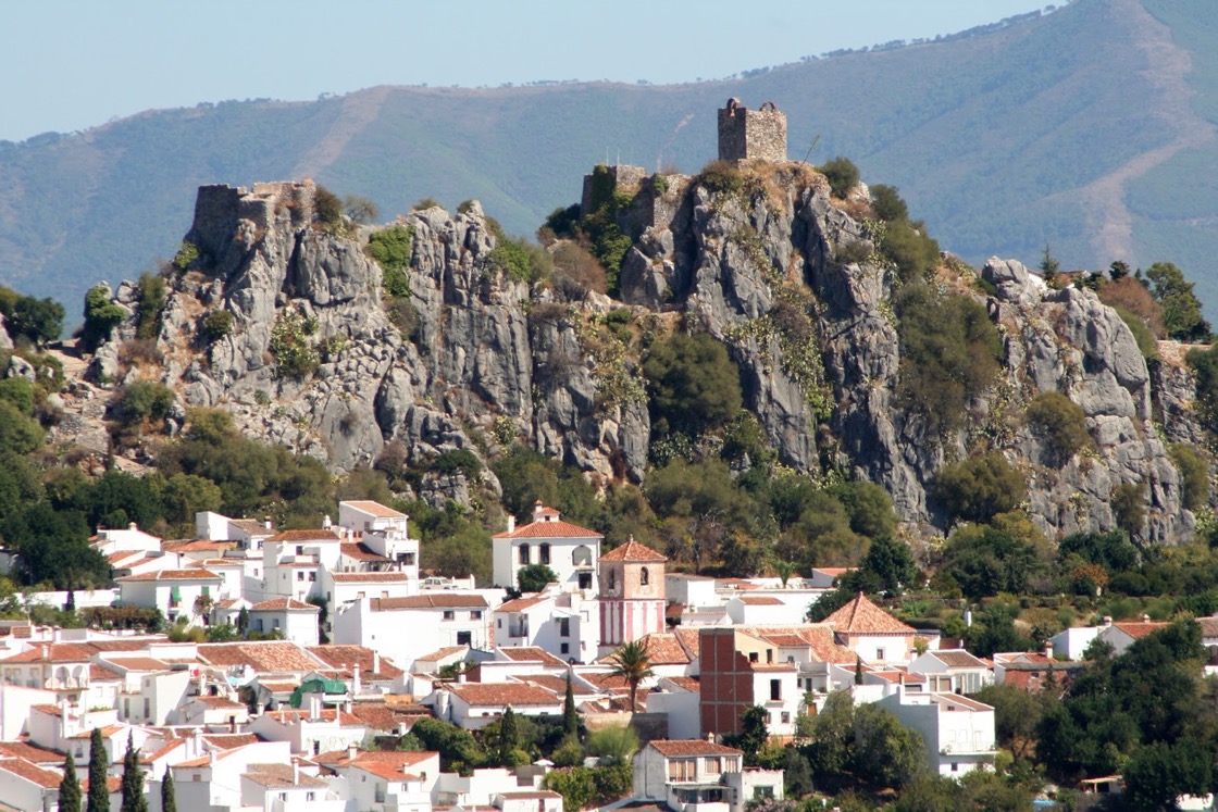
It is a scene that amply repays the traveller for all the désagrémens of his night's lodging, and one which, numerous as were my visits to Gaucín, I always turned my back upon with regret. I do so even now, and proceed on to Ronda, leaving the villages of Algatocin and Benalhauría, situated on the side of the mountain, to the right of the road, and about pistol-shot from it.
In a few miles more, descending by a rough zig-zag track towards the little town of Benidalid, which, with its picturesque castle, stands also somewhat off the road, and immediately under a lofty tor of decomposed rock, distinguished by the name of the 'Peñón de los Frailes' and seems doomed, some day or other, to have the holy mound upon its shoulders.
The next and last village on the road is Atájate, distant about ten miles from Ronda. It is nestled in a narrow pass, overhung on one side by the mountain chain along which the road has hitherto been conducted, and on the other, by a conical crag, whose summit is occupied by the picturesque ruins of a Moorish fortress.
Immediately after passing Atájate, the character of the scenery undergoes a complete change. The mountains become more rugged and arid, rising in huge masses some thousand feet above the road, and are tossed about in curious confusion. Patches of corn and flax are yet here and there to be seen, and the valley beneath is still clothed with cork and ilex, but the vineyards, olive grounds, and chestnut groves, have altogether disappeared, and the villages are far apart, and distant from the road.
On advancing some little way further, all traces of cultivation cease. The road, if a collection of jagged blocks of granite can be so called, traverses a succession of perilous ascents and descents. Sometimes being conducted along the brink of an awful precipice, at others carried under huge masses of crumbling rock. Here and there may, nevertheless, be traced the remains of a paved road, that, in the days of Spain's pride, was made for the express purpose of transporting artillery and stores to the siege of Gibraltar. It is now purposely suffered to go to decay, lest it should offer facilities for making irruptions from that same fortress!
On drawing near the head of the valley, several narrow cut-throat passes present themselves, but, on gaining the summit of the chain, the country becomes more open, and the traveller again breathes freely. A few meagre crops of corn are scattered here and there between the rocks, and the bells of a herd of goats are heard tinkling amongst the gorse and palmeta that fringe the feet of the impending tors, bespeaking the vicinity of fellow man, and giving the traveller a pleasing consciousness of security, whilst he checks his horse to gaze on the splendid scene before hím.
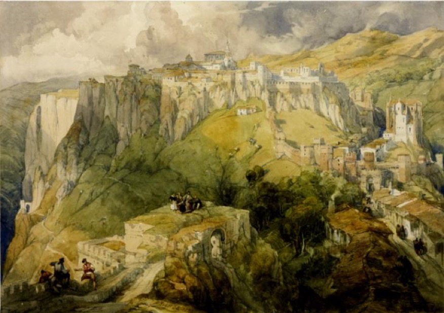
For here the lovely basin of Ronda first bursts upon his view, rich as Ceres and Pomona can make it.
In the centre of the verdant plain, but crowning the summit of an isolated rocky eminence, stands the shining city, its patched and crumbling walls telling of many a protracted siege and desperate assault.
Beyond, the view is bounded by a range of wooded mountains, that forms the western barrier of the secluded basin, and up the rough sides of which, the roads to Cádiz, Seville, and Xeres, may be traced, winding their tedious way.
The descent to Ronda is long, and, from the badness of the road, extremely wearying. The whole distance from Gaucin (about 25 miles) occupied us seven hours.
Ronda Today
Ronda today is a town of about 33,000 inhabitants, and the key tourist attractions are:-
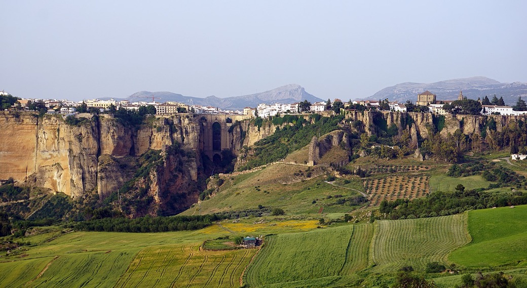
The gorge, Tajo de Ronda, and the cornices is what the tourist really wants to see
The so-called Puente Nuevo (along with the Puente Viejo and Puente Romano) is the symbol of Ronda
The Palacio de Mondragón (once a royal palace, it was closed during out visit)
The bullring of the Real Maestranza de Caballería de Ronda is one of the oldest in Spain
The Bańos Árabes were built in the 13th century and symbolise the tradition where visitors would purify themselves before entering the town
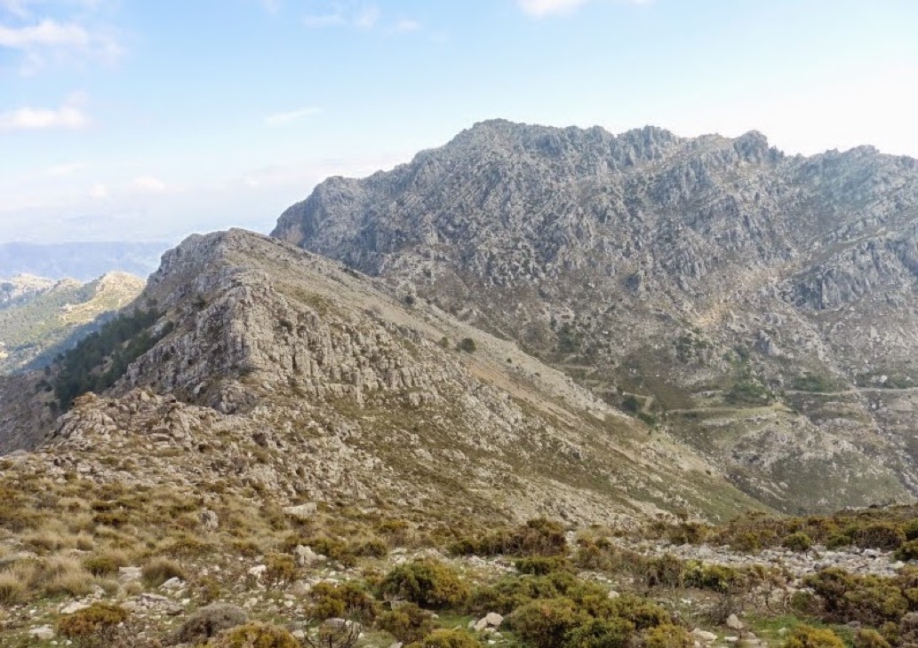
The Alameda del Tajo is a 19th century tree-lined park, with wonderful views over the valley and the Serranía de Ronda in the distance.
I have not been able to find a definitive answer the question "Is Ronda a town or a city?" (Ronda es un pueblo o una ciudad?). According to the best official information I've found, Ronda is a town (pueblo). As far as I know in the province of Málaga there are only six cities, i.e. Antequera, Vélez-Málaga, Coín, Marbella, Fuengirola, and Málaga itself. However, even Wikipedia pages mix things up, and most Spanish language webpages call Ronda a "ciudad". In addition every historical references I've seen calls Ronda a city. So in most cases I'm going with the majority, whatever looks better on the page.
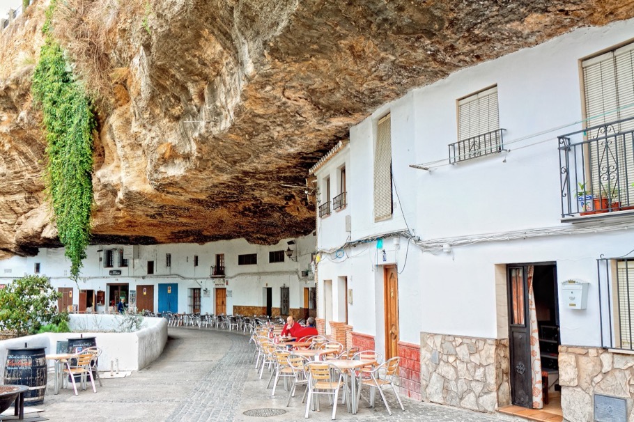
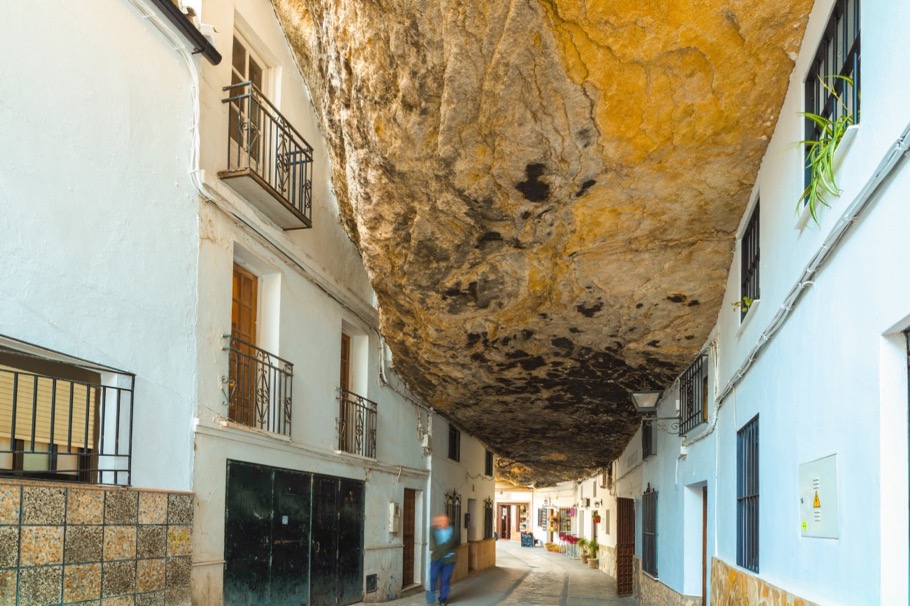
Setenil de las Bodegas
I could not stop myself from adding a footnote to this webpage. Setenil de las Bodegas is just a 30 minute drive north of Ronda and is well worth the detour. Just check out the two photographs below…
And if you like driving (or motorcycle riding) you could consider a round trip past Ronda to the Presa de Zahara-El Gastor, then to Zahara de la Sierra with its rich history and its Mirador (try lunching there), and then through the Parque Natural de la Sierra de Grazalema to the Mirador de Grazalema.
References
Museo de Ronda also has a section on the Historia de Ronda
Ronda y su Serranía
Paseo Geológico por el Tajo de Ronda
Serranía de Ronda
Turismo - Ronda - Patrimonio (Deputación de Málaga)
Andalucia Rustica is a real estate site, but with very useful sections on villages, castles, water dams, and monuments in the region
Baiti has a great section on Ronda