Visiting Spain
last update: 24 June 2020
See Madrid, La Sagrada Família in Barcelona, Cádiz, Málaga, Ronda, the Guggenheim in Bilbao, and the Ciudad de las Artes y las Ciencias in València.
Introduction
Over the past few year we have visited quite a number of the more popular tourist sites in Spain. Below we can see just some of the culturally significant tourist destinations in Spain.
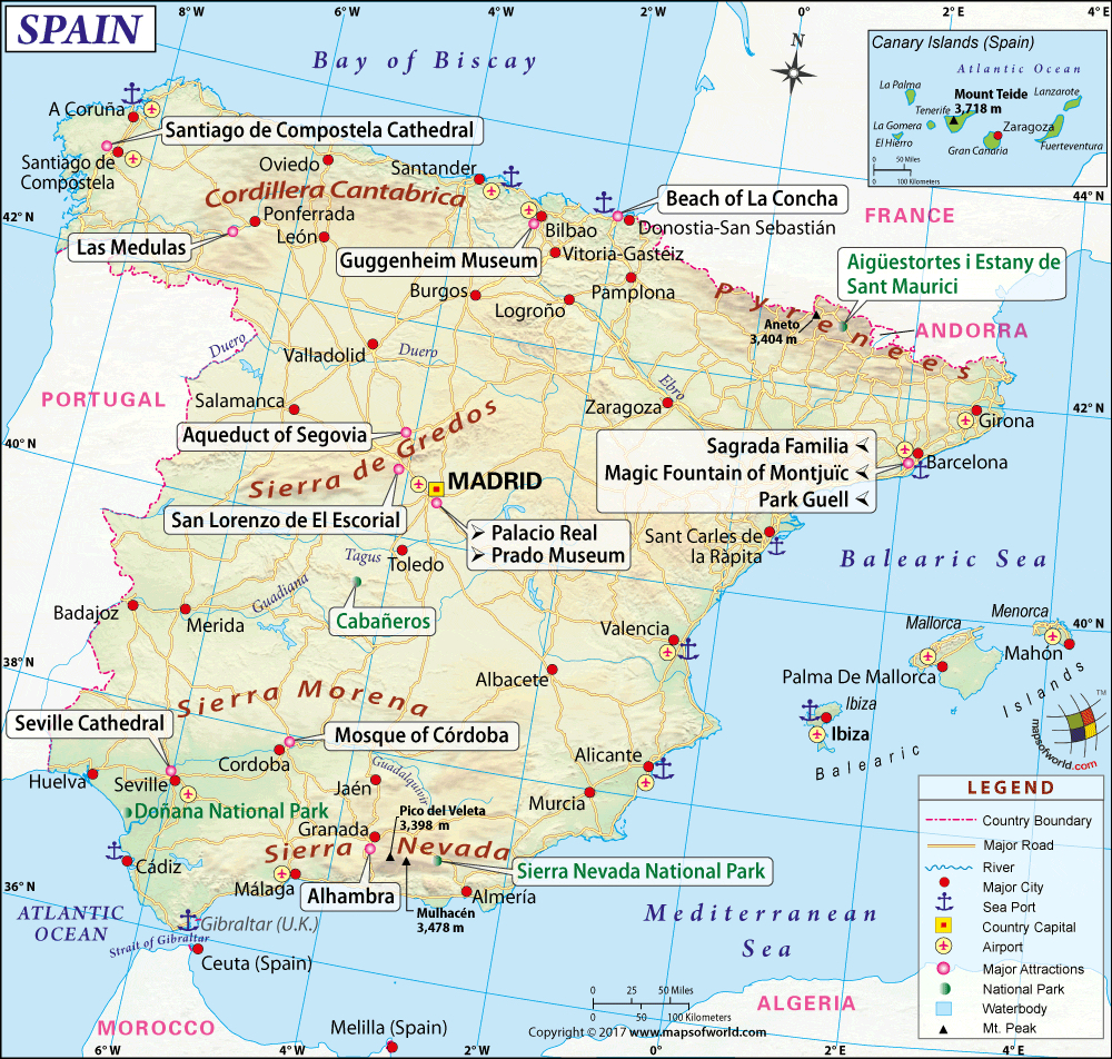
The above map is far from complete, in that places such as Cádiz, Toledo, Valencia, Salamanca,… are also outstanding destinations for the culturally-oriented tourist.
In 2019 Spain was the second most visited country in the world, recording 83.7 million tourists (France was on top). It is claimed that international tourism spending in Spain exceeded $92 billion in 2019, which represented about 10% or 11% of Spain's GDP. The biggest attraction was the Catalonia region followed by the Canary Islands and the Balearic Islands.
Spain is officially called the Kingdom of Spain (Reino de España), and it's a secular parliamentary democracy and a parliamentary monarchy, with King Felipe VI (born in Madrid in 1968) as head of state.
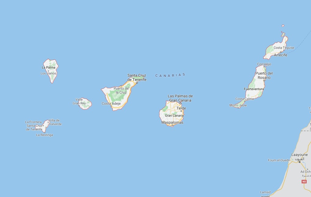
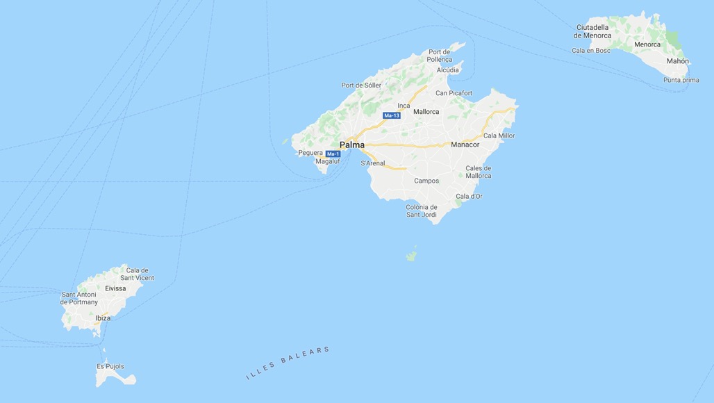
Spain occupies about 82% of the Iberian Peninsula, and in addition its territory also includes two archipelagos: the Canary Islands off the coast of North Africa, and the Balearic Islands in the Mediterranean Sea.
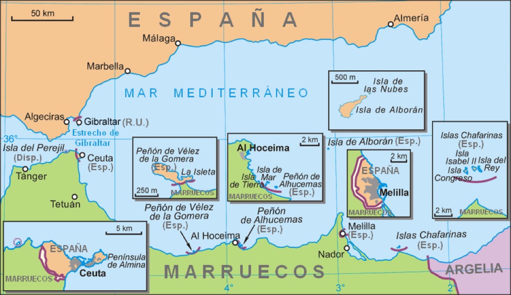
The North African enclaves of Ceuta, Melilla, and the Peñón de Vélez de la Gomera, makes Spain the only European country to have a physical border with an African country (Morocco). Several small islands in the Alboran Sea are also part of Spanish territory, i.e. Alhucemas Islands (with Peñón de Alhucemas, Isla de Mar and Isla de Tierra), Isla de Alborán (with islote de La Nube), Islas Chafarina (with Isla Isabell II, Isla del Rey, Isla Congreso), and finally the disputed Isla del Perejil.
With an area of 505,990 km2, Spain is the largest country in Southern Europe, and the second-largest country in both the European Union (EU) and Western Europe (behind France). It is the fourth-largest country by area on the European continent (after Russia, Ukraine and France). With a population exceeding 47 million, Spain is the sixth-most populous country in Europe, and the third-most populous country in the European Union. Madrid with an urban population in excess of 6 million is both Spain's capital and largest city (in the EU only Paris and the Ruhr are more populous). Other major Spanish urban areas include Barcelona (over 5 million), Valencia (over 1.6 million), Seville (over 1.3 million).
Spain is a major developed country and a high income country, with the world's seventeenth-largest economy by PPP (estimate for 2020). However on a per capita basis Spain dropped to 30th on the list, and it also remained 30th in the 2019 World Happiness Report (so just behind Qatar, Saudi Arabia, Guatemala, Chile, …, but in front of Italy and Poland).
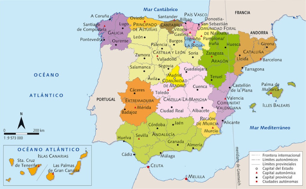
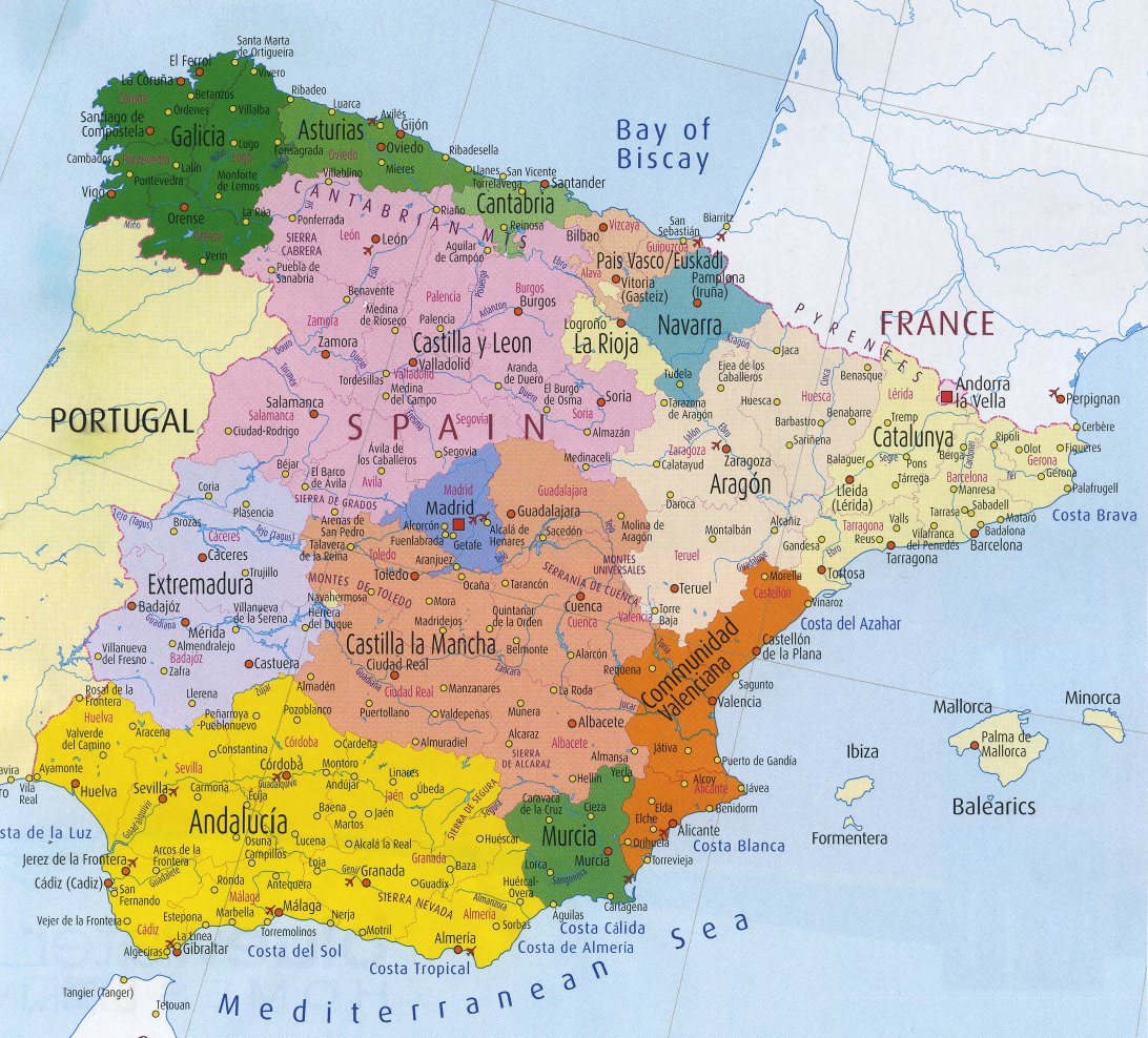
The Spanish State is divided into 17 autonomous communities and 2 autonomous cities. These are Andalusía (capital Seville), Catalonia (Barcelona), Community of Madrid (Madrid), Valencian Community (Valencia), Galicia (Santiago de Compostela), Castile and León (Valladolid), Basque Country (Vitoria-Gasteiz), Castilla–La Mancha (Toledo), Canary Islands (Santa Cruz de Tenerife and Las Palmas de Gran Canaria), Region of Murcia (Murcia), Aragon (Zaragoza), Extremadura (Mérida), Balearic Islands (Palma de Mallorca), Principality of Asturias (Oviedo), Chartered Community of Navarre (Pamplona), Cantabria (Santander), and La Rioja (Logroño), plus the two autonomous cities, Ceuta and Melilla.
In Spain you have a comunidad autónoma, ciudad, villa, municipio, ayuntamiento, comuna, barrio, pedanía,…
Comunidad Autónoma (autonomous community) is a territory endowed with a degree of autonomy. There are 17 autonomous communities, including Andalucía and the Comminidad de Madrid). Each has a autonomous admnstration in the form of a parliament, 'cortes', assembly, or 'junta general'.
Ciudad (city) is an honorary rank granted by monarchs, placing them above towns (villas), villages (aldeas), and places (lugares).
Villa (town) was granted by monarchs, but today has no administrative value. For example Madrid still calls itself a villa (as well as a municipio, a ciudad, capital, and a Comunidad Autónoma).
Municipalidad (municipality) can group one or several localities, and can refer to a city (ciudad) or town (villa). A municipality is governed by a collegiate body called the town hall (ayuntamiento) municipality (municipalidad), alcaldía (mayoralty) or concejo (council), headed by the mayor (el alcalde). In Spain the municipality is the smallest administrative division with its own representative, democratically elected leaders.
Ayuntamiento (town hall) is the governing and administrative body of a municipality. There are 8,131 municipalities in Spain. In principle they each represent at least 5,000 inhabitants.
Comuna (commune) is minor administrative subdivisions, and is in many ways equivalent to municipalities or councils.
Barrio (neighbourhood) is a subdivision of a city (ciudad), town (pueblo) or parish (parroquia), and is inferior to a municipality (municipio).
Pedanía (hamlet) is a territory (minor local entity) that depend on a municipality, but enjoys by law a greater or lesser autonomy. There are more than 3,000 hamlets in Spain.
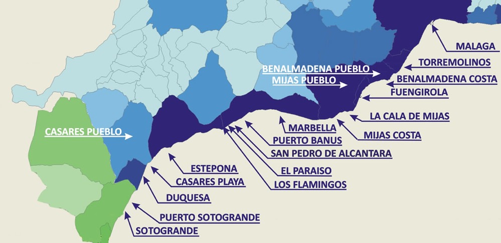
Autonomous communities are divided into provinces, of which there are 50 in total, and in turn, provinces are divided into municipalities. We will look at only one, Andalusía, the second largest community in Spain (the largest is Castile and León). It is divided into eight provinces: Almería, Cádiz, Córdoba, Granada, Huelva, Jaén, Málaga and Seville. And if we look at Málaga, it is divided into 102 municipalities, such as Benahavís, Estepona, Marbella, and Mijas. The coastline of the Province of Málaga is called the Costa del Sol. Below we have a map of the Costa del Sol with some of the famous holiday destinations.
Andalusía might be the second in terms of land area, but it is only the third most important Spanish autonomous community by GDP, behind both Madrid and Catalonia. However, the population of Andalusía are poor, and in terms of GDP per capita it falls to 17th out of the 19 autonomous communities (and only just in front of Extremadura and Melilla).
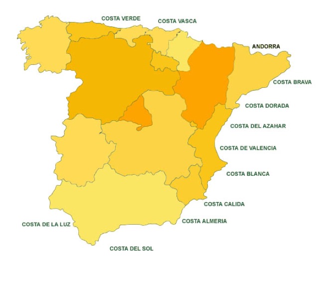
Costa del Sol is just one of the many 'Costas' along the Spanish coastline. Below we have a simple map outlining some of the other costal resort areas, however other maps also include Costa de Morisco (for the northern coast of La Coruña), Costa de Galicia (on the western coast), Costa Cantabria, Costa Almería, and Costa Valencia.
Spanish Climate
It is said that Spain is the most climatically diverse country in Europe, and one of the most climatically diverse countries in the world. Spain has 12 or 13 Köppen climate zones, excluding the Canary Islands.
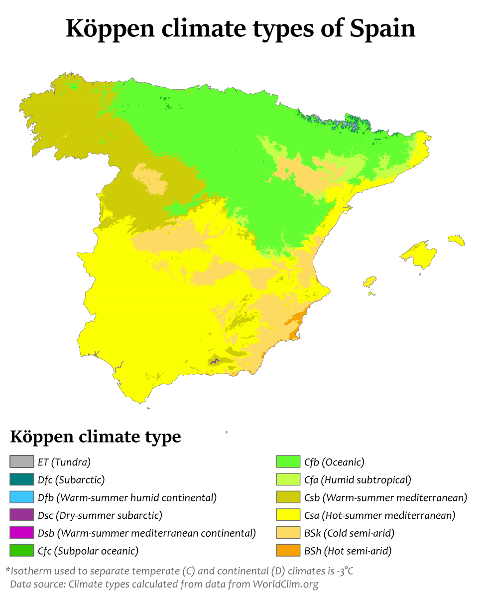
The dominant climate zones are:-
Hot-summer Mediterranean climate characterised by dry and warm/hot summers and cool to mild and wet winters. As we can see, this climate is dominant on the Iberian Peninsula, particularly the variety with summer droughts. It covers all but the far northern part of the country where the Oceanic climate predominates.
Warm-summer Mediterranean climate which predominates in parts of northwestern Spain and mostly inland in central-northern Spain at altitudes above 900-1000 metres.
Oceanic climate is located in the northern part of the country, especially in the regions of Galicia, Basque Country, Asturias, Cantabria, and Navarre. These regions have regular snowfalls in the winter months.
Semiarid climate is predominant in the south-eastern part of the country (Almería province in Eastern Andalusia, Murcia region and Alicante province in Southern Valencia).
Warm-summer continental climate (often called Continental) which can be found in many areas in north-eastern Spain, in areas starting with altitudes above 1000-1100 metres. It can be found also in some areas in the Cantabrian Mountains and the highest areas of the Sistema Ibérico mountain range in central-eastern Spain.
Apart from the five main climate zones, other noticeable sub-zones can be found, such as the humid subtropical climate in large areas in the northern half of Catalonia going down to Barcelona, the province of Huesca and northern Navarre. The dry continental climates all across Spain in the highest areas (notably in the Sierra Nevada and the highest areas in central-northern Spain), the alpine climate and the subarctic climate in the higher areas of northern Spain's various mountain ranges (notably the Cantabrian Mountains and the Pyrenees), a tropical climate in the coastal areas of the Canary Islands and a hot desert climate along the south-eastern coastline, notably around Almería.
To put this in context the hot desert climate around Almería is similar to that found in Dubai and Cairo. The semiarid climate in the Alicante province, Zaragoza, and the Canary Islands is similar to that found in Kabul and Dakar. The Mediterranean climate found in Madrid, Barcelona, and Palma de Mallorca is similar to that found in Naples and Los Angeles. And the oceanic climate of Bilbao, Santiago de Compostela, and Santander is similar to that found in Belgium and southern Chile.
What we have above is interesting, but it does not really help the visitor or tourist.
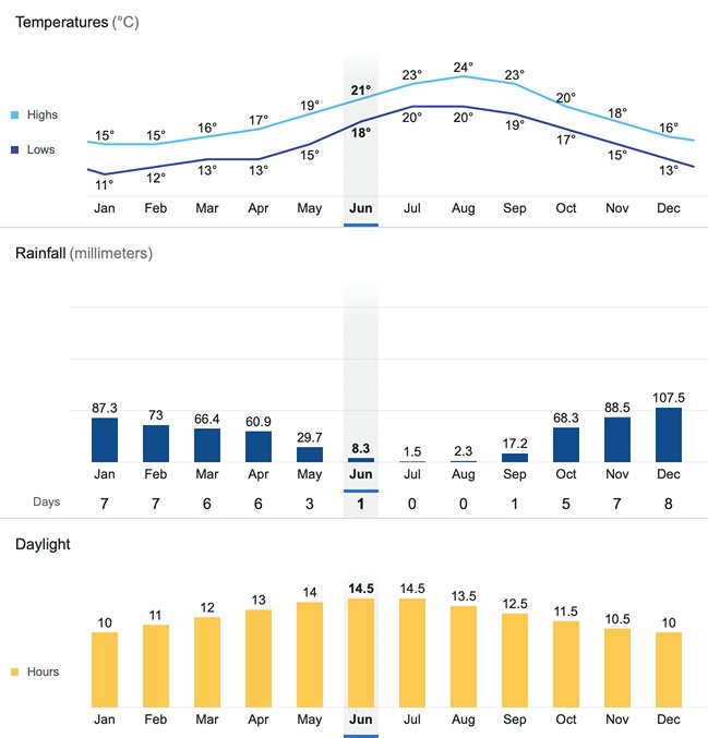
Let's take an example, and look at the furthest point South on the Spanish mainland, so near Punta de Tarifa, which is also the southernmost point of Continental Europe (not far from Cape Trafalgar). We can see above the average temperature, but the region can experience temperatures well in excess of 30°C in the summer, and very occasionally sub-zero temperatures in the winter. What is noticeable is the low rainfall, with an annual average of less than 600 mm. Monthly sunshine hours can approach 300 in the summer months, and are still a very acceptable 140-200 hours/month in the winter. One word of warming, it is always useful to check the sea temperature and wind. The area of Tarifa is known for its strong winds all year round, but the water temperature has been known to reach 23°C to 25°C in the summer months. However, it's far more likely to be around 15°C to 17°C in winter and not much above 20°C to 21°C in the summer (plus a wind chill that can reduced the perceived temperature by up to 3°C or more).
Spanish Geography
Generally mountains are easily defined as being above 2,500 metres, but a combination of altitude and slope is also used to define mountains above 1,000 metres. In the range 300 metres to 999 metres they add a criteria based upon local elevation range to identify mountainous areas. There is a problem on the Iberian Peninsula in that some hills/mountains along the coast extend down to sea level.
Whichever way you look at it, you can see on the above map that Spain is a mountainous country. According to one analysis more than 55% of all Spanish municipalities are defined as 'mountain municipalities', which is similar to Finland, Italy, Sweden, and Slovakia (Switzerland tops the list with 93%). In Spain the 'mountain municipalities' also represent about 55% of total area of the country, but what is more surprising is that in Spain around 38% of the population live in these 'mountain municipalities' (that's nearly 16 million people).
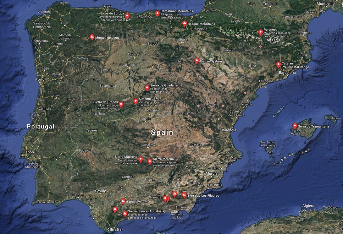
The two largest mountain ranges in Spain are the Sistema Ibérico (highest point 2,313 metres, separates the watersheds of most of Spain's major rivers) and the Baetic System (highest point 3,478 metres, runs along the whole southern coast of Spain).
Then there is the Spanish part of the Pyrenees (highest point 3,404 metres), which is then followed by four smaller mountain ranges, the Galician Massif (highest point 2,121 metres, not visible on the map, is south-east of Ourense), the Sistema Central (highest peak 2,592 metres), the Cantabria Mountains (highest point 2,648 metres), and the Montes de Toledo (highest point 1,603 metres).
Another smaller, but still important, mountain range is the Sierra Morena (highest point 1,332 metres), which is followed by the Catalan Costal Range (highest point 763 metres), the Montes de León (highest peak 2,199 metres), and the Basque Mountains (highest peak 1,551 metres).
The Canary Islands is home to Spain's highest mountain, the Teide on Tenerife. The peak is 3,718 metres above sea level, but is about 7,500 metres above the ocean floor. This makes Teide the third tallest volcano in the world when measured from the base on the ocean floor.
Finally the Balearic Islands is home to some small peaks, the highest being 1,064 metres. In fact whilst the Canary Islands were formed by volcanic activity, the Balearic Islands were formed by Tectonic uplift.
It is interesting in that perhaps the best known mountain range in Spain is the Sierra Nevada, but it is in fact included in the larger Baetic System. The Sierra Nevada provides Spain its 2nd, 4th and 6th highest peaks, and the Mulhacén, at 3,478 metres, the highest mountain in the Iberian Peninsula. In fact the Sierra Nevada is home to 15 peaks over 3,000 metres.
It is not clear how to define what rivers are. Do you use hydrology, or perhaps it's geomorphology, or maybe the biological processes present in rivers? Of course a river can look quite different as it moves from it source to a sea or ocean. It can also look different depending upon the seasons. Discharge looks quite satisfying, in particular if the river is nice and wide and drains a large area. We can define very large rivers, down to small rivers, and even define streams and small streams, and even brooks (very small and shallow stream).
In global terms, the most dominant river is the Amazon, which discharges in excess of 200,000 cubic metres/second. That is more than the next six largest rivers in the world combined, including the Congo and the Yangtze. In fact Europe has only a handful of very large rivers, notably the Volga (which drains an unusually large area into the Caspian Sea), the Danube (which drains into the Black Sea), the Pechora (which drains into the Barents Sea), the Rhine (which drains into the North Sea), and the Neva (a very short river that drains Lake Ladoga into the Baltic Sea).
As a point of comparison the Rhine is 1,233 kilometres long, drains about 200,000 square kilometres, and discharges around 2,900 cubic metres/second. The Neva has a discharge of 2,500 cubic metres/second (or the equivalent of one large swimming pool per second).
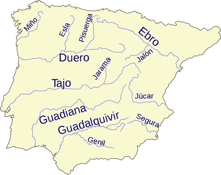
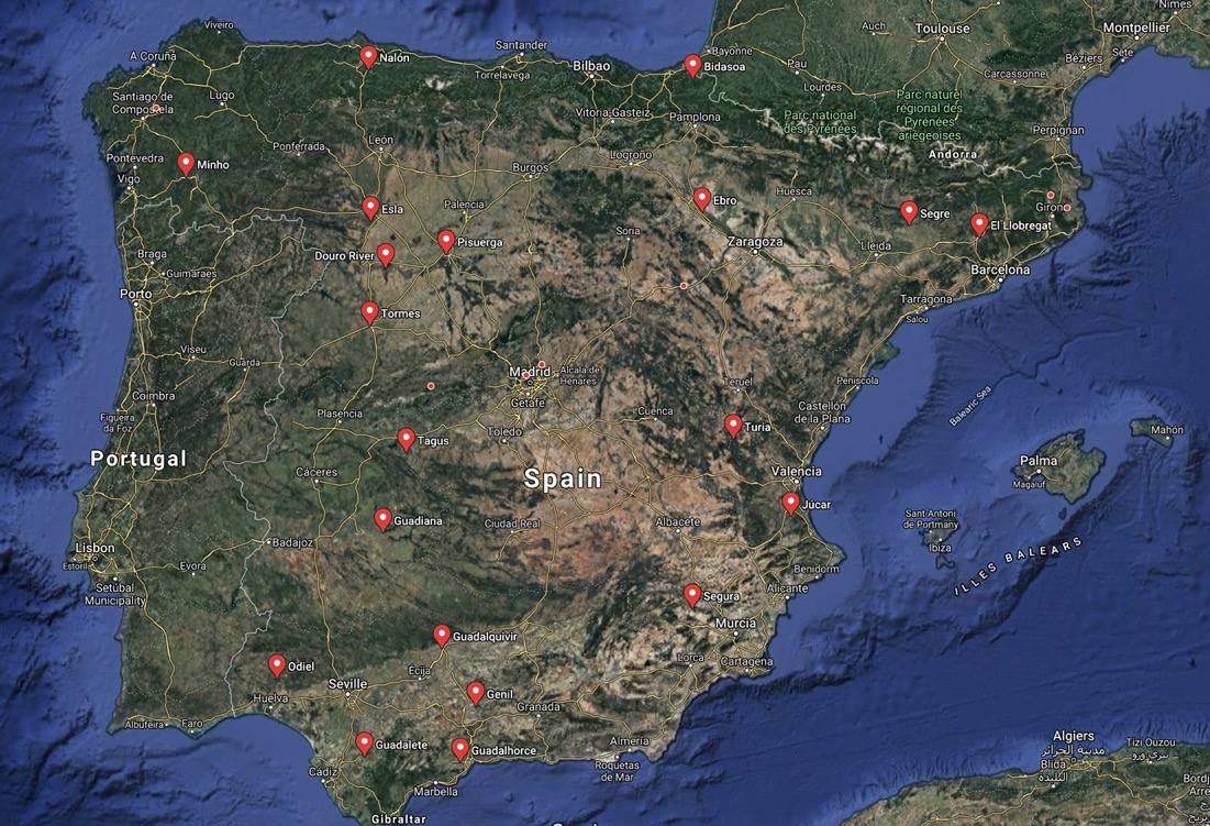
Spain's main rivers are the:-
Tagus (Tajo) has its source in Aragon and is longest river in Spain (1,007 kilometres), and discharges an average of 500 cubic metres/second into the Atlantic Ocean, near Lisbon (it also goes through regions of Aranjuez and Toledo, so passes near Madrid).
Ebro has its source in Cantabria and is the second longest river in Spain (930 kilometres), and discharges an average of 426 cubic metres/second into the Mediterranean, near Tarragona (and passes through Zaragoza).
Douro has its source in Castile and León, and is long 897 kilometres. It discharges an average of 700 cubic metres/second into the Atlantic Ocean, near Porto (it also goes through the regions of Burgos, Valladolid and Salamanca).
Guadiana has its source in Castile-La Mancha, and is long 818 kilometres. It discharges an average of about 80 cubic metres/second into the Gulf of Cádiz, in the Algarve (it also defines a part of the Portugal-Spain border).
Guadalquivir has its source in Jaén, and is long 657 kilometres. It discharges an average of about 160 cubic metres/second into the Atlantic Ocean, near Cádiz (it also goes through Córdoba and Seville).
Minho (Miño) has its source in Galicia, and is long 350 kilometres. It discharges an average of about 420 cubic metres/second into the Atlantic Ocean on the Galician coast.
It's worth noting that the Garonne, which flows through France to port of Bordeaux, actually has it source in the Aran Valley in the Spanish Pyrenees.
Technically the claim is that the Tagus and the Douro are Spain's longest and third longest rivers, however they actually pass through Portugal (as does the Guadiana). So in fact the Ebro and the Guadalquivir are the first and second longest rivers that have their entire length in Spain.
Spain's National Parks only represents 0.73% of Spanish territory, although it is claimed that it's socio-economic impact influences about 3.5% of the Spanish territory. Global figures are patchy, but some African countries protect around 10% of their territory, e.g. Botswana (9.7%), Gabon (10%), Namibia (13.2%), and Zambia claims to protect 32% of its territory. In Asia, Bhutan (20.8%), Israel (30%), and Nepal (23.4%) are the frontrunners. In North and Central America its Costa Rica (25.1%) that set the example, and in South America, Chile (19.3%), Colombia (12.5%), Ecuador (12.2%), Paraguay (14.9%) and Venezuela (21.8%) are good examples. Even Brazil claims to protect 3% of its territory.
In Europe, Iceland (12.1%) leads the way, but many countries protect between 5% and 10% of their territories. Spain, with only 0.73% of its territory protected, is one of the worst in Europe, but the one that we can say really is the worst of the pack is Belgium with only 0.2% of its territory protected. Greenland has only one national park, but it is the largest in the world, and covers 44.8% of the country.
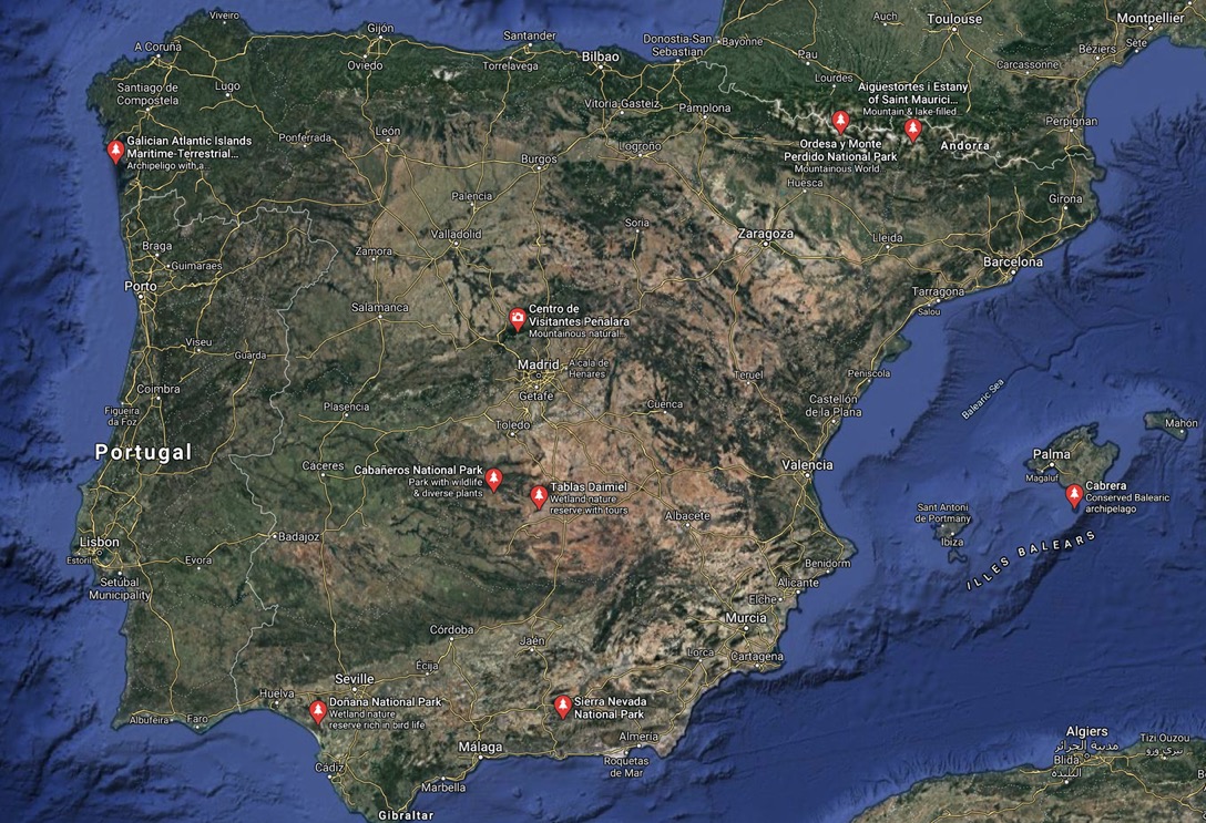
Spain's National Parks are as follows (by descending size):-
Cabrera Archipelago - 90,800 hectares (is a mixed maritime-terrestrial park in the Balearic Islands, but almost all is maritime)
Sierra Nevada - 85,883 hectares
Picos de Europa - 67,127 hectares (part of the Cantabria Mountains)
Doñana - 54,252 hectares (costal nature reserve in Huelva)
Cabañeros - 40,856 hectares (part of Montes de Toledo)
Guadarrama - 33,960 hectares (part of the Sierra de Guadarrama in the regions of Segovia and Ávila)
Sierra de las Nieves - 23,000 hectares (part of the Serranía de Ronda)
Teide - 18,990 hectares (centred on Mount Teide on Tenerife)
Monfragüe - 18,369 hectares (is near Cáceres)
Ordesa y Monte Perdido - 15,608 hectares (in the Pyrenees)
Aigüestortes i Estany de Sant Maurici - 14,119 hectares (in the Pyrenees)
Illas Atlánticas de Galicia - 8,480 hectares (is an archipelago of four islands and is mostly a maritime park)
Timanfaya - 5,107 hectares (is on Lanzarote)
Caldera de Taburiente - 4,690 hectares (is on the island of La Palma)
Garajonay - 3,984 hectares (is on the island of La Gomera one of the Canary Islands)
Tablas de Daimiel - 3,030 hectares (is a wetland in La Mancha)
Note: 1 hectare is 10,000 m2 or a square with 100-metres sides
Note: Greenlands only national park covers 97 million hectares, that's approaching twice the total surface area of Spain
It's been estimated that in excess of 15 million people visit the Spanish national parks annually, and that Teide on Tenerife represents more than 25% of that.
Spanish agriculture
I must admit that I found the Wikipedia article Agriculture in Spain a fascinating read, and below I have cherry-picked a few things I felt were interesting or even surprising:-
20.6 million hectares of land in Spain is suitable for cultivation, from a total of about 50.5 million hectares.
Spain has the second largest proportion of land devoted to agriculture in Europe, just behind France.
In 2018 Spain was the world's largest producer of olives, 2nd largest producer of tangerines and almonds, 3rd largest producer of oats and artichokes, 4th largest producer of grapes and peaches, 5th largest producer of barley and child peppers, 6th largest producer of oranges, apricots and strawberries, 7th largest producer of lemons, 8th largest producer of tomatoes and rye.
In 2019 Spain exported the equivalent of 49 billion € is agricultural products, importing only 31.5 billion € agricultural products.
Spain produces 51% of all olive oil in the EU-27, 16.7% of all vegetables and horticultural products, 30% of all sheep and goats, 21% of all pigs, and 13% of all poultry.
Spain received no EU subsidies for olive oil, milk, and animals.
There are nearly 1 million farm holdings in Spain, employing more than 800,000 people.
Reference
I'm a great fan of maps, and I love websites full of maps. So I can't help but put my only reference as the Atlas Nacional de España (del siglo XXI). Unfortunately, but it looks to be only in Spanish.
Section III is devoted to Historia, and includes maps on Neolithic sites, communication routes in Hispania Romana, las Primeras Taifas, 16th and 17th century cities, and the 19th century rail network.